by Jason Wu
The El Paso/Ciudad Juárez region is one of the world’s largest binational border metropolises. Multiple border crossings with heavy traffic (like this region has) can cause logistical challenges for transportation agencies. Secure, efficient technology solutions — including those that leverage the benefits of intelligent transportation systems — can help agencies while helping to guide traffic safely through the border.
Through a project sponsored by Texas A&M Transportation Institute’s (TTI’s) Center for International Intelligent Transportation Research (CIITR), I and my colleagues are looking at applying 3D light detection and ranging (LiDAR) sensors at the U.S.–Mexico border. Applied to autonomous vehicle (AV) applications, LiDAR can enable AVs to “see” surroundings with high precision and clarity. My research with CIITR and TTI’s Safety through Disruption University Transportation Center broadens the possible application of LiDAR in transportation.

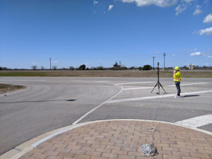
As pictured here, my team and I collect data for LiDAR research on The Texas A&M University System’s RELLIS Campus.
For example, LiDAR sensors can capture high-resolution and highly accurate traffic information in real time to help border agencies analyze, plan and improve logistics at border crossings. In a work zone, better information can enhance safety for construction workers as well as drivers. I call these roadside or infrastructure-based LiDAR applications.
In the future, my team will pilot test a LiDAR-based system for monitoring multimodal traffic at international ports of entry in the El Paso/ Ciudad Juárez region. The system will detect and track object — including vehicles, motorcycles, pedestrians, and bicyclists — with a high degree of accuracy. It will provide border management a 360-degree view of crossings, which is useful in traffic management and security screening. That kind of micro-level traffic data can help agencies develop strategies to alleviate congestion and mitigate issues like travel delay experienced by travelers. Previous center research has demonstrated LiDAR’s potential for producing accurate, reliable traffic information in a border context. Our team will evaluate the system for completeness, accuracy, reliability and sensitivity.
Taking advantage of these user-friendly technologies now will help border management tighten their operations and logistics as we continue the transition to a connected traffic environment. On a larger scale, we can strengthen national (and international) infrastructure by leveraging LiDAR to make travel safer, more reliable and more economically beneficial to local communities.
Jason Wu, associate research scientist, works in TTI’s Research and Implementation Program in Dallas.


