If you’ve ever visited the Texas-Mexico border during peak crossing times, you know a lot of time is spent waiting to cross. And, as the old saying goes, time is money. That’s particularly true for shippers moving goods and manufacturing materials from point A in Mexico to point B in the United States.
My colleagues and I at the Texas A&M Transportation Institute’s (TTI’s) Center for International Intelligent Transportation Research (CIITR) have conducted a number of research projects over the past twelve years to mitigate wait times and better understand traffic patterns. Our research has helped improve, among other things at the border:
- Estimating wait- and crossing-times more accurately.
- Calculating real-time traffic volumes.
- Counting the number of vehicles at a given (or multiple) border crossing(s).
- Identifying how many lanes (and what type of lanes) are open.
- Determining accurate travel times on both sides of the border (and from point A to point B).
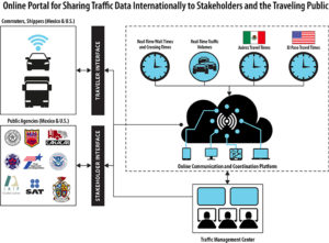
Though these projects have produced useful results on their own, tying all that data together into one useful product can leverage a whole greater than the sum of the parts. We have an opportunity to pull together these innovative data collection techniques into a single online communication and coordination platform. We can make a better, bigger picture out of these several, smaller pictures.
Who would use it? Shipping companies, certainly, to better predict route travel times, but also tourists planning a trip across the border. Every public agency in the El Paso Region (on both sides of the border) could access the platform and mine its data for what they need—from EMS agencies to traffic management centers to U.S. Customs and Border Protection. Anyone that needs the information would have access to it via the Internet.
Users would simply click onto a website to answer travel questions:
- What are the traffic volumes along my route?
- What are the wait times and crossing times (updated in real time) at the various border crossings in Texas?
- How long will it take to get from my home or business in Juárez to the border?
- Once I get there, what are the traffic conditions in El Paso like?

The online portal would coordinate different data sources into a web-based information platform accessible by transportation agencies and commuters and shippers on both sides of the border.
How would the website help? With better, more complete information at hand, more accurate trip planning becomes possible. By checking the online information, for example, you could avoid that long line of traffic waiting at the Paso del Norte Bridge and reroute to the Stanton Street Bridge instead. And fewer waiting cars (and trucks) reduces the level of auto emissions polluting the air at the border, making the region healthier for everyone. Congestion lessens, trade flow loosens up, and air quality improves.
The various U.S. and Mexican transportation agencies could better coordinate traffic management, something that is sorely missing cross-border. For example, once a border crossing becomes congested, a digital message sign could be displayed upstream directing truckers to another crossing instead.
And it’s not just today’s travelers that can benefit from this web-based resource. Local communities like El Paso can use the data for future planning when expanding the region’s transportation network. Having a more accurate picture of today’s traffic patterns can help troubleshoot similar issues of congestion, wait times, and pollution tomorrow by enabling more accurate, reliable and resilient infrastructure planning.
In short, we’ve got the pieces of the puzzle. Now we need the solution that will let travelers, shippers and stakeholders put the puzzle together in whatever way they need to. That solution is an integrated, online communication and coordination platform. We just need to build it.

